Illustrated Map of Sao Joao da Madeira City Map by Jose Miguel Cardoso |
Home > Winners > #60850 |
 |
|
||||
| DESIGN DETAILS | |||||
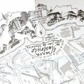
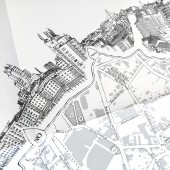
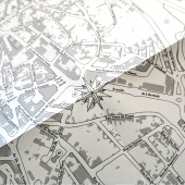
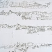
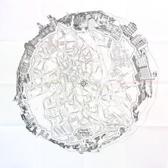
| DESIGN NAME: Illustrated Map of Sao Joao da Madeira PRIMARY FUNCTION: City Map INSPIRATION: This map is inspired in the tradition of creating Portulano charts in the Portuguese discoveries and the urge to describe the world through observation, from the golden era of Dutch painting. In this impetus to describe the world, we travel the places and draw. But why do we draw? We draw because we want to be lost. Because only when we are lost, we can find ourselves again. Aren’t these drawings symbolic notations of our experience of places, and therefore, maps of our world consciousness? UNIQUE PROPERTIES / PROJECT DESCRIPTION: This map presents a solution for the paradox between the freedom and uncertainty of the discourse of the observational drawing and the accuracy and security of the cartographic representation. The paradox is solved by a metaphorical dialogue between the two languages. The observer in the center of the map is framed by a 360 degree panorama of the city landscape, offering a direct relationship between the map and the surrounding landscape, stimulating the sense of place. It can be read upside down. OPERATION / FLOW / INTERACTION: The rose of the winds is placed in the center of the composition, marking the position of the observer, towards the landscape. The map is circumvented in by a frame made with a 360 degree panorama city of the city landscape, offering a direct relationship between the map and the surrounding landscape. When the user traces a line from the center to some building in the landscape, it intersects the same building in the map. The convention of the North on top is not mandatory, because the map can be read upside down, always relating the streets with the corresponding landscape. PROJECT DURATION AND LOCATION: This project was commissioned by the Parish Council of the city of Sao Joao da Madeira, with the purpose of being launched at the 8th Illustration Meeting in October 2016. The city is represented as a small world, at the center of the Portuguese illustration. The panoramic view was drawn from the top of the City Hall building on the 7th floor, the floor occupied by the Mayor's office. It offers a perspective of the city usually inaccessible to citizens. FITS BEST INTO CATEGORY: Graphics, Illustration and Visual Communication Design |
PRODUCTION / REALIZATION TECHNOLOGY: 24 very slow contour observational drawings, made with BIC ballpoint pen on papel. Illustration refined on Adobe Illustrator software. Map layout made with Adobe Indesign. SPECIFICATIONS / TECHNICAL PROPERTIES: Unfolded: 680mm x 680mm. Folded: 170mm x 170mm. TAGS: Landscape drawing, Map design, World Description, Sense of Place, Wayfinding RESEARCH ABSTRACT: The idea for this project comes from the research I did in the context of a Master's Degree in Drawing in which I questioned how the drawing can change the perception of the landscape. This research continues today in the PhD context, questioning if there is a Genius Loci that demands its own description, maps "tailored to the body" of places. A mixed research method is used between reflection and action, in which design strategies are designed with the aim of being applied in the representation of places by different authors. Drawings are published through exhibitions and experimental guides of cities, which are seen and adopted by agents of the tourist areas of Portugal, for example linked to gastronomy and wines. These maps and city guides filled with drawings of their landscapes contain an empathic character that provokes positive emotions in their audiences, stimulating the meaning, memory and identity of places. CHALLENGE: The most difficult part of this challenge was getting access to a place in the city where you could have access to a 360-degree panoramic view and could also spend many days drawing. It was not a matter of drawing, but where to draw. Fortunately, I was able to count on the Mayor's authorization to meet me in this part of the building. It was also necessary to schedule the mornings and afternoons of draw, depending on the availability of the various offices and employees who occupied them. In this sense it was very important to win the sympathy of the people and to reconcile their privacy needs with my project. ADDED DATE: 2017-09-21 20:05:21 TEAM MEMBERS (1) : IMAGE CREDITS: Jose Miguel Cardoso, 2017. PATENTS/COPYRIGHTS: Copyrights belong to José Cardoso, 2016. |
||||
| Visit the following page to learn more: http://www.josecardoso.eu/?p=1503 | |||||
| AWARD DETAILS | |
 |
Illustrated Map of Sao Joao Da Madeira City Map by Jose Miguel Cardoso is Winner in Graphics, Illustration and Visual Communication Design Category, 2017 - 2018.· Press Members: Login or Register to request an exclusive interview with Jose Miguel Cardoso. · Click here to register inorder to view the profile and other works by Jose Miguel Cardoso. |
| SOCIAL |
| + Add to Likes / Favorites | Send to My Email | Comment | Testimonials | View Press-Release | Press Kit |
