Scenic Path Along Guixeres Landscape Recovery by Batlle i Roig Arquitectura |
Home > Winners > #118334 |
 |
|
||||
| DESIGN DETAILS | |||||
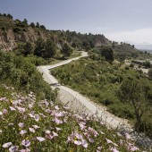
| DESIGN NAME: Scenic Path Along Guixeres PRIMARY FUNCTION: Landscape Recovery INSPIRATION: The project is framed within Igualada’s Green Ring, creating a set of pedestrian and bicycle paths as a belt around the city. This new green sustainable mobility infrastructure aims at establishing a network of free spaces, apt for environmentally friendly leisure activities, adapting and recovering, to great extent, currently underused or degraded spaces. In this context, the gypsum mines path implies the adaptation of a 1,65km section, of which 800 meters have already been accomplished. UNIQUE PROPERTIES / PROJECT DESCRIPTION: The project has two main goals: first, connectivity, achieving the continuity of this global project around the whole city (the green ring). Second, landscape and biodiversity recovery, establishing the necessary elements to generate a new dynamic on the site that will progressively improve its environmental conditions through the use of collected water. In this sense, the proposal creates a typical section with three clearly differentiated strips that adapt to the different situations of the layout, addressing the problems of the site as well as developing its potential. OPERATION / FLOW / INTERACTION: The intervention creates a landmark visible from afar (the viewpoint) that acts as a reclamation for the whole city and encourages the use of space. Also, the path is completed with a number of small living areas strategically placed on the most privileged areas. This section of the path ends in a final observation deck cantilevering over the mountain providing a panoramic view of the Anoia and Montserrat Mountain. The project has had an exceptional reception from the citizens. They flock to stroll and practice sports in their leisure time. This has motivated the municipality to go on with additional segments of the track to continue extending this Green Path around the city. PROJECT DURATION AND LOCATION: The project, located in Igualada (next to Barcelona, Spain) started in May 2017 and finished in January 2018. |
PRODUCTION / REALIZATION TECHNOLOGY: The central strip, with the main 3-metre-wide granitic-sand track, guarantees the continuity of the Green Ring. The outer strip is a linear lookout overlooking the city. A 1.2-metre-wide track paved with concrete to ensure the accessibility and using luminescent aggregate to improve visibility during the evening. The layout of this linear scenic viewpoint recognises the principal existing landmarks, vegetation and trees by widening and creating rest areas. The inner strip acts as a plant ditch, to channel runoff and generates a safety strip to stop minor landslips. These same fallen rocks are used to build a sequence of retaining areas to filter and rechannel this water to new points where vegetation has been planted to colonise the place. SPECIFICATIONS / TECHNICAL PROPERTIES: 5.600 sqm / 800 meters long TAGS: Landscape Recovery, Pedestrian Path, Cyclable Lane, Rest Areas, Viewpoint, Architecture Landscape, Biodiversity RESEARCH ABSTRACT: The proposal’s innovation lies in the result of this process of analysis and synthesis that concludes with the technification of conventional solutions for path construction, in order to accomplish greater performance regarding accessibility, visibility, durability and re naturalization of the environment, with an optimum cost ratio and maximum efficiency regarding environmental footprint. CHALLENGE: The project was born and built during the crisis, for which we had a very small budget available. We were asked just to solve a new path through that location in order to ensure the continuity of the Igualada Green Ring, but the knowledge acquired about the site and its values forced us to take the whole former gypsum mines as our scope of work. We did not want to design a project of a simple path, oblivious to everything observed and its potentials. Our desire was to recover the entire area, historically abandoned, and integrate it into the green and social infrastructure of the city. ADDED DATE: 2021-02-12 12:28:56 TEAM MEMBERS (9) : Architect: Enric Batlle, Architect: Joan Roig, Architect: Ivan Sanchez, Architect: Mario Súñer, Architect & Landscape Architect: Livia Valentini, Agriculture Engineer & Landscape Designer: Dolors Feu, Agricultural Engineer & Environmentalist: Yago Cavaller, Building Engineer & Landscape Designer: Diana Calico and IMAGE CREDITS: Image #1: Photographer Jordi Surroca, Guixeres (1), 2018. Image #2: Photographer Jordi Surroca, Guixeres (2), 2018. Image #3: Photographer Jordi Surroca, Guixeres (3), 2018. Image #4: Photographer Jordi Surroca, Guixeres (4), 2018. Image #5: Photographer Jordi Surroca, Guixeres (5), 2018. Video Credits: Stupendastic Films PATENTS/COPYRIGHTS: Copyrights belong to Batlle i Roig Arquitectura, 2020. |
||||
| Visit the following page to learn more: https://bit.ly/2Zsjum1 | |||||
| AWARD DETAILS | |
 |
Scenic Path Along Guixeres Landscape Recovery by Batlle I Roig Arquitectura is Winner in Urban Planning and Urban Design Category, 2020 - 2021.· Read the interview with designer Batlle i Roig Arquitectura for design Scenic Path Along Guixeres here.· Press Members: Login or Register to request an exclusive interview with Batlle i Roig Arquitectura. · Click here to register inorder to view the profile and other works by Batlle i Roig Arquitectura. |
| SOCIAL |
| + Add to Likes / Favorites | Send to My Email | Comment | Testimonials | View Press-Release | Press Kit |
Did you like Batlle I Roig Arquitectura's Urban Planning Design?
You will most likely enjoy other award winning urban planning design as well.
Click here to view more Award Winning Urban Planning Design.


